
June 27, 2023 – TheNewswire – Vancouver, B.C.: VR Resources Ltd. (TSXV:VRR), (FSE:5VR); (OTC:VRRCF), the “Company“, or “VR”, is pleased to provide the results from the recently completed airborne gradient magnetic survey and ground-based 3D array DCIP survey on its New Boston property in Nevada.
-
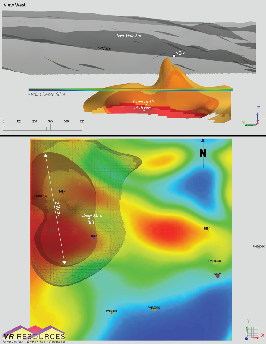
Figure 1: 15mV/V IP anomaly 950 m long, from surface to 500 m depth and open, which outlines the target for a mineralized porphyry intrusion below the Jeep Mine in the western part of the system of mineralized sheeted veins exposed on surface over a 2,100 m strike length;
-
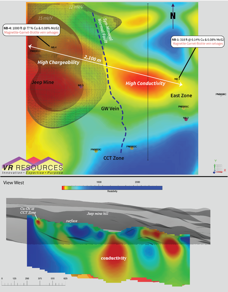
Figure 2: High amplitude conductivity anomaly 900 m long, from surface to 500m depth and open, which outlines the target for a high temperature, mineralized porphyry-skarn center at East Zone in the eastern part of the system of sheeted veins at New Boston;
-
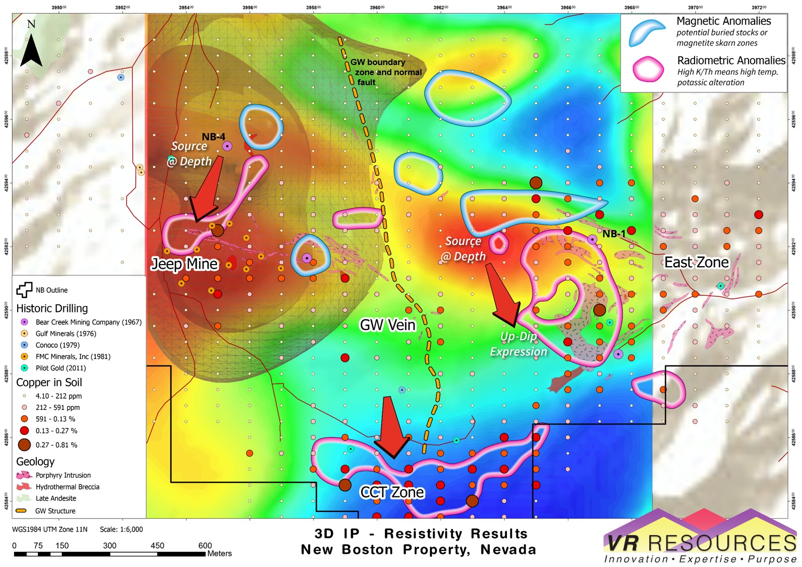
Figure 3: Integrated exploration target map; the conductivity anomaly at East Zone is the inferred porphyry source to the quartz veins with copper exposed on surface at East Zone and CCT Zone;
-
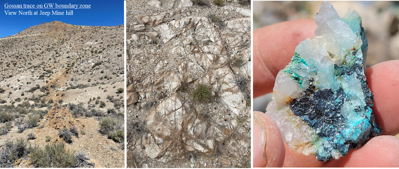
Figure 4: Field photographs by VR along the GW boundary zone and normal fault which separates the IP and conductivity targets for mineralized porphyry centers at Jeep Mine and East Zone respectively. The fault is itself mineralized; it forms a continuous gossan of quartz veins and quartz vein stockwork with limonite and copper wad replacing massive chalcopyrite (copper sulfide);
-
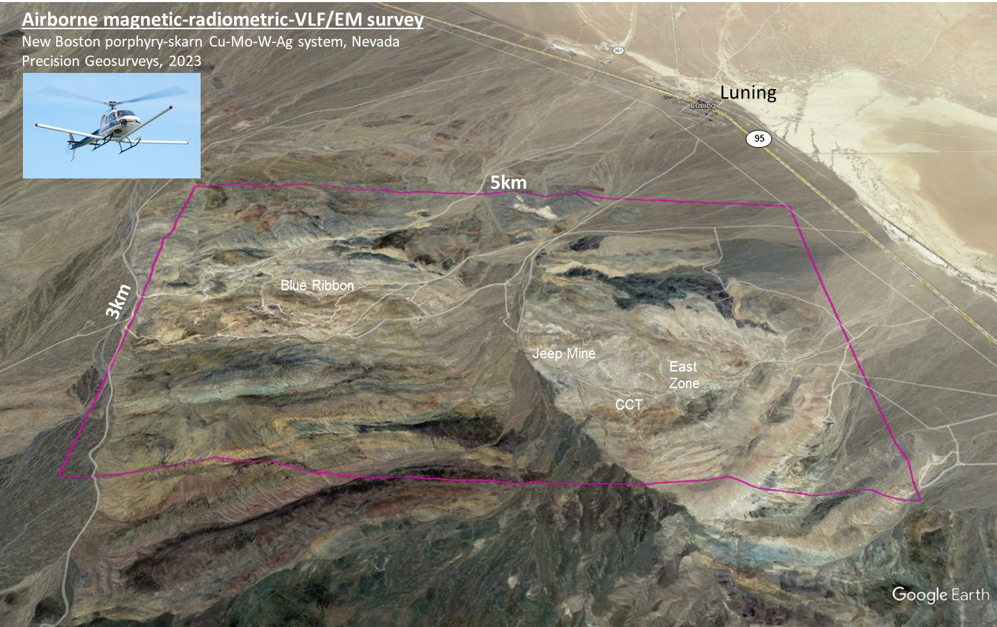
Figure 5. Satellite image showing the 4 km east-west breadth of the fully zoned skarn and polymetallic porphyry system exposed on surface at New Boston.
From VR’s CEO, Dr. Michael Gunning, “Technology matters. Surface work and reconnaissance drilling at New Boston by Conoco, Gulf and Bear Creek in the 1960s and 70s established the sheer scale of the porphyry-skarn system across a strike length of 4 km of sheeted and stockwork veins exposed on surface, and significant grades and thickness of moly’ mineralization in numerous drill holes (see Figure 6). But a sector collapse in 1981 left that work unfinished with regard to identifying and drilling a mineralized porphyry intrusion as the source for the sheeted and stockwork veins exposed at surface. Some forty years later, new multi-sensor gradient magnetics and 3D array DCIP geophysical technologies that were not available to Conoco at the time now provide VR with a clear path forward to complete the story and undertake the drilling that was actually proposed by Conoco to follow up on the garnet-magnetite-biotite stockwork veins observed in drill holes NB-1 and NB-4 on either end of the system.
Conoco developed a 3.14 BT exploration model to encompass the mineralized sheeted veins at New Boston, exclusive of a porphyry stock that was inferred but not identified at the time. By using the results from new high-tech geophysical surveys, we believe that we can build on that model and confirm the presence of a mineralized porphyry centre (s) as the source for the system of sheeted veins at surface.
Our goal is to drill test the two main IP and conductivity targets illustrated in this news release this fall. As shown in the satellite image in Figure 5, the proximity of New Boston to state HWY 95 provides tremendous logistical advantages for drilling and advanced-stage exploration.
I encourage our shareholders to review carefully the figures herein to fully appreciate the clarity, strength and scale of the two targets now apparent at New Boston; detailed explanations are provided in the figure captions to help. With that, we look forward to providing further updates as our exploration advances.
Technical Information
Summary technical and geological information for the Company’s various exploration properties including New Boston is available at the Company’s website at www.vrr.ca.
Technical information for this news release has been prepared in accordance with the Canadian regulatory requirements set out in National Instrument 43-101. Justin Daley, P.Geo., VP Exploration and a non-independent Qualified Person oversees and/or participates in all aspects of the Company’s mineral exploration projects, and the content of this news release has been reviewed on behalf of the Company by the CEO, Dr. Michael Gunning, P.Geo., a non-independent Qualified Person.
About the New Boston Property
Location
New Boston is within the Walker Lane mineral belt and structural province in west-central Nevada. More specifically, it is within the co-spatial belts of Jurassic and Cretaceous aged copper and moly porphyry deposits, including the Yerington camp and Hall deposit.
New Boston is located in the Garfield Range in Mineral County, approximately 150 km southeast of Reno. Vegetation is sparse in the range; outcrop or colluvium predominate on the property itself, with quaternary cover developed off its eastern border and eastern flank of the range.
The property location facilitates cost-effective exploration, year-round. Access is from the nearby town of Luning located just 5 km to the east on State Highway 95 connecting Reno and Las Vegas. The property itself is criss-crossed by a myriad of active, historic trails and roads which are reachable from the highway.
Property Description
The New Boston property is large. It consists of 77 claims in one contiguous block approximately 3 x 5 km in size and covering 583 hectares in total (1,441 acres). It covers the entire extent of the known copper-moly-silver porphyry-skarn mineral system exposed on surface between Blue Ribbon and East Zone, and its inferred down-dip potential to the north.
The property is on federal land administered by the Bureau of Land Management (BLM). There are no state or federal land use designations, or privately-owned land which impede access to the property, nor is the property within the BLM’s broadly defined area of sage grouse protection.
The property is owned 100% by VR. There are no underlying annual lease payments, nor are there any joint venture or back-in interests. The vendor of the property retains a royalty.
About VR Resources
VR is an established junior exploration company based in Vancouver (TSX.V: VRR; Frankfurt: 5VR; OTCQB: VRRCF). VR evaluates, explores and advances opportunities in copper, gold and critical metals in Nevada, USA, and Ontario, Canada, and most recently, a kimberlite breccia pipe discovery and field in northern Ontario. VR applies modern exploration technologies and in-house experience and expertise in greenfields exploration to large-footprint systems in underexplored areas/districts. The foundation of VR is the proven track record of its Board in early-stage exploration, discovery and M&A. The Company is well-financed for its mineral exploration and corporate obligations. VR owns its properties outright and evaluates new opportunities on an ongoing basis, whether by staking or acquisition.
ON BEHALF OF THE BOARD OF DIRECTORS:
“Michael H. Gunning”
____________________________
Dr. Michael H. Gunning, PhD, PGeo
President & CEO
For general information please use the following:
Website: www.vrr.ca
Email: [email protected]
Phone: 778-731-9292
Forward Looking Statements
This press release contains forward-looking statements. Forward-looking statements are typically identified by words such as: believe, expect, anticipate, intend, estimate, postulate and similar expressions or those which, by their nature, refer to future events. Forward looking statements in this release include those related to the companies upcoming plans, such as “Our goal is to drill test the two main IP and conductivity targets illustrated in this news release this fall.”, “the size of the exploration target”, and “VR evaluates new opportunities on an ongoing basis.”
This news release may contain statements and/or information with respect to mineral properties and/or deposits which are adjacent to and/or potentially similar to the Company’s mineral properties, but which the Company has no interest in nor rights to explore. Readers are cautioned that mineral deposits on similar properties are not necessarily indicative of mineral deposits on the Company’s properties.
Although the Company believes that the use of such statements is reasonable, there can be no assurance that such statements will prove to be accurate, and actual results and future events could differ materially from those anticipated in such statements. The Company cautions investors that any forward-looking statements by the Company are not guarantees of future performance, and that actual results may differ materially from those in forward-looking statements. Trading in the securities of the Company should be considered highly speculative. All of the Company’s public disclosure filings may be accessed via www.sedar.com and readers are urged to review these materials.
Neither the TSX Venture Exchange nor its Regulation Services Provider (as that term is defined in Policies of the TSX Venture Exchange) accepts responsibility for the adequacy or accuracy of this release.
————————————————————————————————————-
Click Image To View Full Size
Figure 1. The target for a mineralized porphyry intrusion below the Jeep Mine as identified by a 950 m long IP anomaly, shown overlain on a resistivity base map derived from 3D array DCIP survey at New Boston in 2023. Lower = plan map; Upper = cross-section view, located along the double white arrow in the plan map. Note: 1. New Boston is a low-pyrite system, so the core IP isoshell at 15mV within a 12 mV halo is interpreted as base metal sulfide concentrations. 2. The IP anomaly at depth corresponds to increasing conductivity, below the surface expression of the Jeep Mine hill; 3. Drill hole NB-4 with 992 ft @ 0.08% MoS2 is located north of the conductivity core to the large IP anomaly.
Click Image To View Full Size
Figure 2. The target for a mineralized porphyry center at East Zone as identified by the conductivity anomaly derived from 3D array DCIP survey at New Boston in 2023. Upper = plan map; Lower = cross-section view located along the north-south black line on the plan map. Note: 1. The high amplitude of the conductivity anomaly indicates concentrated sulfide minerals; 2. Conductivity target has 900 m strike length, and extends from surface to 500 m depth in the 3D DCIP model and is open to depth; 3. Drill hole N-B1 with 318 ft @ 0.14% copper and 0.08% moly is located at the eastern end of the conductivity anomaly; 4. The conductivity anomaly correlates with high temperature potassic alteration index in soil geochemistry and potassium enrichment indicated by the airborne magnetic and radiometric survey (see Figure 3).
Click Image To View Full Size
Figure 3. Integrated exploration map for New Boston. Shown are IP iso-shells plotted on conductivity base map derived from the 3D array DCIP survey in 2023, on a background of shaded topography. Also shown are anomalies derived from the airborne, multi-sensor gradient magnetic survey with radiometrics completed in 2023. The GW boundary zone and normal fault which separates the main IP and conductivity targets for mineralized porphyry centers at Jeep Mine and East Zone respectively, is itself mineralized (see photos in Figure 4). The 900 m long conductivity anomaly and target at East Zone is interpreted to be the mineralized porphyry center and source for copper that migrated up-dip in limestone country rock to surface mineralization at CCT zone (see Figure 2).
Click Image To View Full Size
Figure 4. Field photogrpahs by VR along the GW boundary zone and normal fault. It is based on geological mapping and sampling by VR, and is supported by the new geophysical data shown in Figures 1, 2 and 3. It forms a continuous gossan zone of quartz veins and quartz vein stockwork with limonite and copper wad after massive chalcopyrite (copper sulfide). The structure follows the topographic high of Jeep Mine hill where marbelization of limestone is strongest but copper veins at surface lessen with topographic elevation on the hill; however, copper is evident in both modern ICP-MS soil geochemical data, and in the new DCIP anomalies reported herein. Overall, the GW boundary zone separates the large IP anomaly targeted as the porphyry center below Jeep Mine from the high amplitude conductivity anomaly at East Zone which is targeted as the mineralized porphyry center feeding the copper veins exposed on surface at CCT Zone (see Figure 3).
Click Image To View Full Size
Figure 5. Satellite image showing the large-footprint of the polymetallic porphyry-skarn system exposed over an east-west strike length of 4 km between Blue Ribbon and East Zone at New Boston, and its ideal location just 5 km from Luning on state HWY 95 connecting Reno and Las Vegas in west-central Nevada.
Click Image To View Full Size
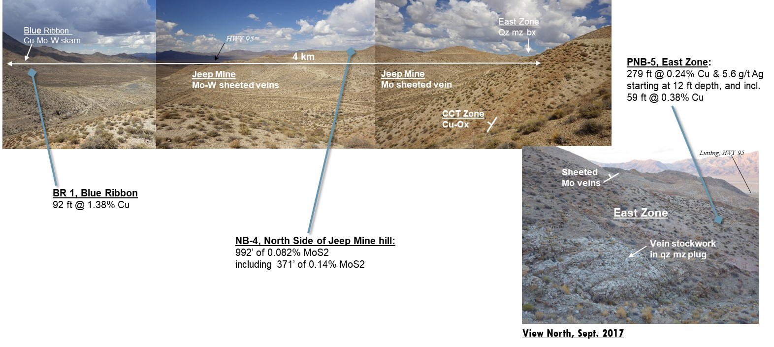
Figure 6. Panoramic photo from the field by VR in 2017. The potential of New Boston is about scale, and location: sheeted and stockwork veins with copper, molybdenum and silver are exposed on surface over a strike length of approximately 4 km across the skarn and porphyry system, and; it is located less that 5 km from Highway 95 connecting Reno and Las Vegas in west-central Nevada. Historic drill intersections are from internal company reports; their locations are shown in Figures 1 and 2 – they are peripheral to the new geophysical targets for mineralized porphyry centers feeding the system of mineralized veins exposed on surface.
Copyright (c) 2023 TheNewswire – All rights reserved.